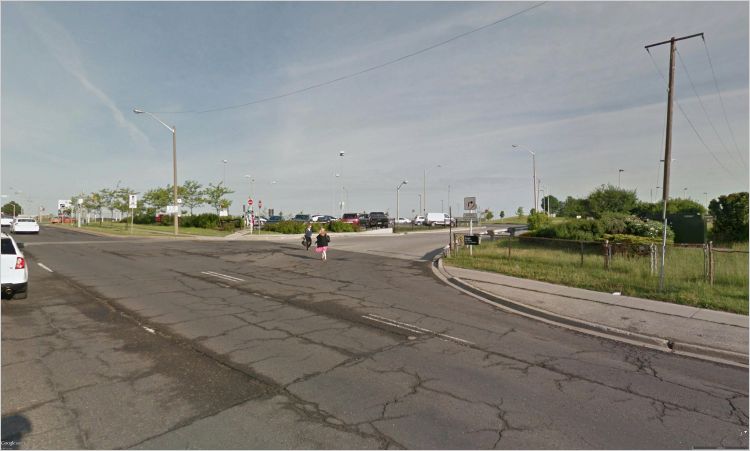
The area surrounding a subway station has a real impact: transit riders must walk across a six-lane road if they want to access Wilson station on foot. Image: Google Earth.
Last month, we published a blog that examined densities around transit stations in the Greater Toronto Area (GTA). Our analysis showed that outside of Toronto’s downtown core, only five subway stations meet the level of density recommended by Metrolinx to support a subway.
That’s bad news on the whole, but it raises an interesting question. What makes those five suburban stations successful in terms of urban development, compared to all the others that aren’t?
Three of the five stations in question are in North York, along the Yonge line. There’s another subway corridor that runs through North York — the Spadina-University line — for which the density around stations is much lower. In fact, many stations along the upper stretches of the Spadina-University line don’t meet the density levels recommended to support streetcar service, let alone a subway.
What’s happening in North York?
Comparing stations along these two lines can help us understand the shape that different densities take. The table below compares three stations in the more densely developed Yonge corridor (Finch, North York Centre and Sheppard) with three in the less developed Spadina corridor (Wilson, Downsview and Yorkdale).
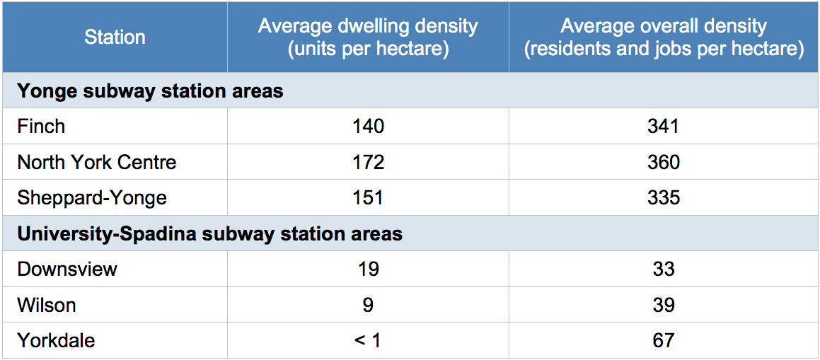
Density of areas within 800 metres of subway stations.
The difference in density between the two corridors is striking: the Yonge subway station area densities are more than seven times higher than those of the Spadina stations. This is due largely to the different character of these areas.
For example, one might assume that there would be a large number of jobs around Yorkdale station because Yorkdale Mall is nearby. Although there are many businesses in the mall, this does not provide as many jobs as the office towers along the Yonge corridor.
Similarly, there are not many people living near Yorkdale, Wilson and Downsview stations. These stations are mostly used as transfer hubs, serving transit riders that arrive by bus from suburban neighbourhoods that are farther away. This is a sharp contrast with all of the residential buildings along Yonge Street.
Amenities require density
These low densities matter for transit, but they also have implications for the livability of the neighbourhood — including the quality and quantity of amenities available. Without enough density to support local businesses, there will be fewer amenities within walking distance. Here’s is a comparison of amenities around the two North York subway segments:
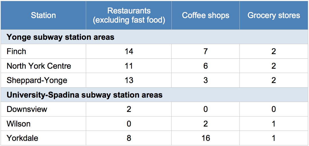
Number of amenities located within 800 metres of subway stations.
There are more restaurants, coffee shops and grocery stores within a 10-minute walk of each station along the Yonge corridor than the Spadina corridor. The sole exception is Yorkdale station, which is connected to the Yorkdale mall and therefore has many coffee shops (as well as fast food restaurants) nearby.
But as the earlier table showed, even with the mall, the densities around Yorkdale station are roughly one-quarter of what is considered optimal. The mall may provide businesses and jobs, but the residential density is low: there are only 1,430 people living within 800 metres of the station, compared to the 11,060 residents at Sheppard-Yonge station, which also has a mall nearby.
The geographical distribution of these amenities is also important. The map below shows the catchment area of each station — that is, the area within a 10-minute walk — along with nearby restaurants, coffee shops, grocery stores and parks. Note that most of the amenities near Yorkdale station are in the mall, but there are not many shops accessible from the street.
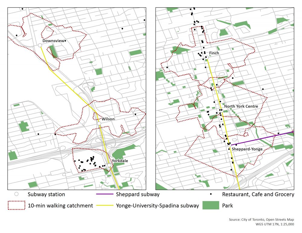
Locations of walkable amenities around subway stations.
Walking in the suburbs
Of course, distance isn’t the only factor that affects walkability. We also analyzed the pedestrian-friendliness of the neighbourhoods around these subway stations. Ideally, a transit hub should enable seamless trips between work, home and stores without the need for a car.
Wilson, Downsview and Yorkdale stations are all rather difficult to access by foot. The development around them is clearly optimized for parking or drop-offs by cars and local buses.
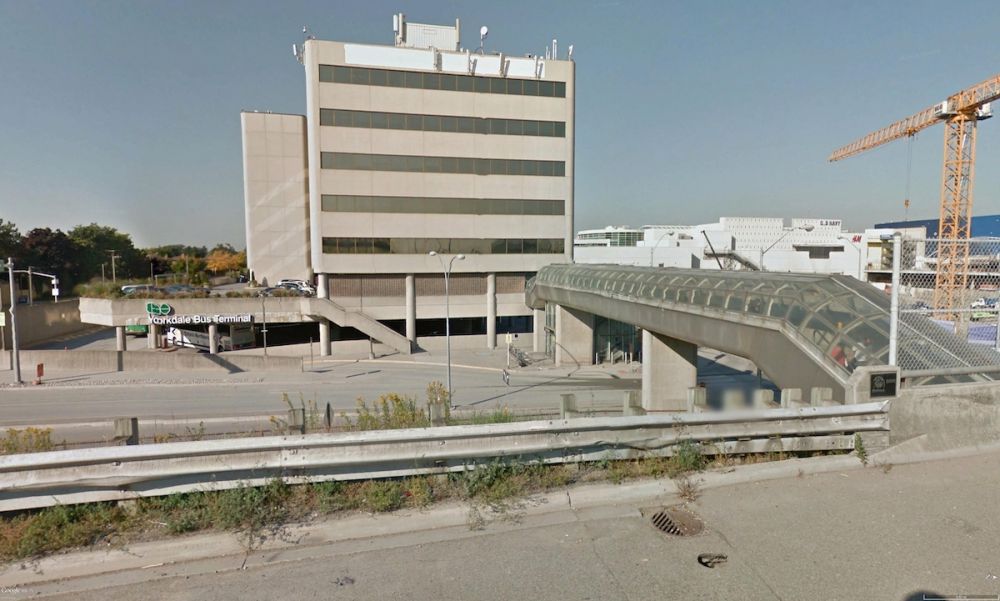
Yorkdale Mall and the subway transit hub prioritize access by car, while pedestrians have to use an elevated walkway to cross the street. Image: Google Earth.
The main barrier to pedestrian-friendliness around the Spadina stations are the large thoroughfares, such as Highway 401 and Allan Road. They are built to prioritize free-flowing vehicular traffic, but not a safe and pleasant walking environment, as can be seen in the image above.
The neighbourhoods around the Yonge corridor stations have clear street grids, making it easy to walk around them and access the nearby residential areas. The sidewalks on Yonge Street are wide, which allows them to accommodate the large number of people that live and work in the area. There are also subtle design elements like island medians, which allow people to cross the street between intersections, as well as crosswalks made of differentiated pavement — a signal to drivers that they are sharing the road with pedestrians.
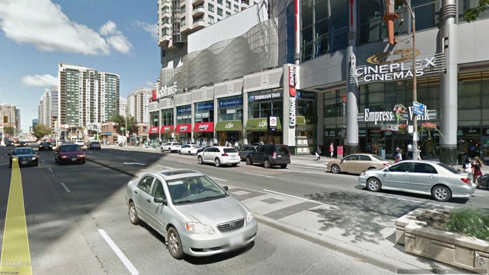
Yonge Street has wide sidewalks and street medians, and more stores are pedestrian-oriented with street entrances. Image: Google Earth.
Building up around subways
As the GTA’s population grows rapidly, we need to locate more people near transit in order to reduce dependence on cars. That’s crucial to cut carbon pollution and improve our air quality, as well as to make intelligent use of the land available to us. Building "up" by increasing density reduces the need to build new greenfield developments — allowing us to preserve lands like the Greenbelt for important uses like farming and providing clean water.
If the GTA is going to do intensification right, subway corridors are a great place to start. As we invest in higher-order transit across the region, we need to prioritize projects where intensification is possible. That means assessing the development opportunities around proposed transit lines, and making investments on that basis. This will ensure that we can provide more homes and jobs in the places where people want them, while also contributing to our environmental goals.

Nithya Vijayakumar was a senior advisor leading transportation and urban development projects in the Pembina Institute’s Ontario office until 2017.